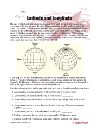
7th Grade Map Resources
-
MAPS
Latitude and Longitude Worksheet
Latitude and longitude are imaginary lines universally accepted as coordinates for locating places on Earth. Students…Subjects:Social Studies and HistoryMapMathematics -
MAPS
Political Map of the Western Hemisphere
Use this printable map with your students to provide a political and physical view of the Western Hemisphere. After…Subjects:Social Studies and HistoryGeographyMap -
MAPS
Latitude and Longitude Map
This printable outline map of the world provides a latitude and longitude grid. Use this social studies resource to help…Subjects:Social Studies and HistoryGeographyMap -
MAPS
Color World Map
Use this printable colorful map with your students to provide a physical view of the world. After learning about this…Subjects:GeographyMap -
MAPS
Map Library – the World
Here you'll find printable maps of the world, each of the continents, regions of the world, and more.Subjects:Social Studies and HistoryMap -
WORKSHEETS
Map Library
Browse through a selection of printable maps of the U.S. states, U.S. regions, continents, and more. Plus, use our…Subjects:Social Studies and HistoryMap -
MAPS
What Are Latitude and Longitude?
Give your students practice with geographic coordinates in this activity . In this printable worksheet, students will…Subjects:Social Studies and HistoryMap -
MAPS
New England
This blank map of the New England area with the states outlined is a great printable resource to teach your students…Subjects:Social Studies and HistoryU.S. StatesMap -
EDITOR'S COLLECTIONS
World Maps Gallery
Explore the world through printable maps depicting continents, countries, capitals, climate zones, oceans, landforms,…Subjects:Social Studies and HistoryMap -
MAPS
German Nazi Takeover: 1933-1944
Use these maps to illustrate the German takeover of Europe from 1933-44.Subjects:Social Studies and HistoryWorld War II (1939-1945)Map -
MAPS
Map Library – United States
Find different printable maps of each state in the U.S. There are physical maps, maps with capitals, and maps of…Subjects:Social Studies and HistoryU.S. StatesMap -
MAPS
How Do You Read a Weather Map?
After identifying each of the symbols used on a weather map, students will use a map to answer questions about weather…Subjects:ScienceWeatherMap -
MAPS
Seeing the World Sub Kit (Grades 7-8)
Use this substitute teacher kit for grades 7-8 that focuses on the development of geography skills.Subjects:Social Studies and HistoryGeographyMap -
MAPS
Political and Physical Map of Australia and New Zealand
Use this printable map with your students to provide a political and physical view of Australia and New Zealand. After…Subjects:Social Studies and HistoryGeographyMap -
MAPS
Climate Zones Map
Teach your students about how maps can be used to illustrate different information. Use this map to help students…Subjects:Social Studies and HistoryMapEarth Science -
MAPS
What Are Climate Zones?
After labeling the climate zones on a world map in this Earth science printable, students will classify conditions…Subjects:ScienceEarth ScienceMap -
GAMES AND APPS
Map Library – Activities
These printable mapping activities are sure to keep your students engaged in learning geography. There are crossword…Subjects:Social Studies and HistoryGeographyMap -
MAPS
Outline Map of Europe
This blank map of Europe with the countries outlined is a great printable resource to teach your students this contents…Subjects:Social Studies and HistoryMapEurope -
EDITOR'S COLLECTIONS
Maps & Activities Printables Slideshow
With this slideshow, you'll discover great maps and geography-related activities to utilize in the classroom. All of…Subjects:GeographySocial Studies and HistoryMap -
MAPS
Eastern Hemisphere Map
Use this printable map with your students to provide a physical view of the Eastern Hemisphere. After learning about…Subjects:Social Studies and HistoryGeographyMap -
MAPS
Political Map of Europe
You can use this printable map to provide a political view of Europe. It will not only help your students improve their…Subjects:Social Studies and HistoryGeographyMap -
MAPS
Chart Columbus's Voyages
Students plot the course of Columbus's various expeditions on a map of the world.SubjectsSocial Studies and HistoryMapAustralia and New Zealand -
MAPS
Map of Asia
Use a printable outline map that depicts Asia to enhance your geography or history lessons. A map scale is included,…Subjects:Social Studies and HistoryMapAsia -
MAPS
Map of the United States
This printable outline of the United States of America is a great printable resource to build students geographical…Subjects:Social Studies and HistoryMapUnited States of America (USA)