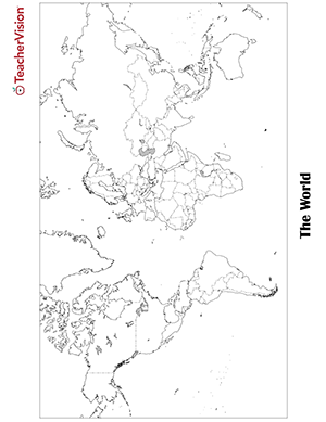
Blank world map worksheet with countries - outline, non-labeled template with borders - print or download.
Blank World Map Worksheet - Free PDF Printable
This blank world map worksheet...
- Can be easily downloaded and printed as a PDF
- Displays all continents and countries with borders but without labels and names
- Prints in 8.5" x 11" landscape for easy reading and copying
- Is unlocked for adding text labels and can also be labeled or colored by hand
- Can easily be turned into a Google Slide for projection
- Integrates with Google Classroom in either Slides, Docs, or PDF format
- Supplements geography, history, politics, cultural, and social studies lessons
How to Use this World Map Worksheet
Use this blank world map worksheet to:
- Supplement your geography, social studies, or history lessons
- Give a blank world map quiz - have students label countries and continents
- Teach students about different continents, countries, landmarks, political boundaries, and cultures
- Encourage students to take their learning further by illustrating or coloring in the map to make it look even more realistic
Why Teach Mapping Skills?
In our era of real-time GPS, map, and navigation applications on virtually every handheld device, plus full-color maps with incredible detail and precision on hundreds of websites, many people ask the question "Why teach mapping skills to students when they can just use technology?"
That's a good question. But, as it turns out, there are several good and reasonable answers!
The skills needed to read and interpret a map are about more than just finding directions. Mapping skills also help students:
Build and enhance visual learning skills
Learning to map will help students’ visual learning skills, which, in turn, will help them with other subjects like math (graphing) and science (estimation)
Understand distances
By learning mapping skills, students will develop the ability to estimate and understand distances between places or objects.
Learn to make spatial comparisons
Mapping helps students make spatial comparisons, as well as develop a sense of scale (i.e. countries indicated on a map are shown in scale).
Analyze and quantify data
Learning to map helps students understand how to analyze and quantify data - for example, reading topological maps that show erosion, changing coastlines, new volcanoes, etc.
So, give your students a head start on developing important academic and life skills by teaching them how to read a map in your geography, social studies, or history classes.
Extension Activities for this Blank World Map Worksheet
Further develop your geography or social studies lessons with the following lesson plans, activities, and units…
Maps: Practicing Map Skills
A great hands-on, supplemental activity to a map skills unit! A simple geography printable gives your class the chance to practice their map skills. The worksheet calls for students to imagine they are on a field trip and must use their knowledge of map reading to not get lost.
Maps: City, State, Country, Continent
A printable social studies activity for your students that focuses on identifying and categorizing geographic terms. This can also be used as a supplemental practice or assessment to ensure students have recalled all important information.
Lesson Plan: Latitude and Longitude
This 40-minute latitude and longitude lesson plan will help students understand how latitude and longitude are used to identify places on a map.
Project-Based Learning Unit (Grades 4-6): Create an Annotated Map
A comprehensive lesson on Westward Expansion, Mapping, and the California Gold Rush. Packed with hands-on inquiry-based activities, extensions and enhancements, cross-curricular independent and group work, and engaging and interactive challenges.
Find More Printable Maps
Visit the map library to find hundreds of blank and labeled maps of the United States, blank US state maps, labeled US state maps, blank country maps, topological maps, and other geography maps of the world free to print and download.

