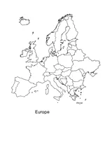


Europe Map Printable Activity
This Europe map printable is a great resource to teach your students about the continent and geographical features of Europe. This map is an excellent way to challenge your students to color and label all the countries. It is also a helpful classroom tool to teach students about the development of countries in Europe.

How to Use This Europe Map Printable
This blank Europe map printable can be used to teach both geography and history.
Teachers can use it to teach students about the geographical features of Europe. Ask students to label bodies of water, mountain ranges, and other physical features. It can also be used to teach about the political geography of Europe, asking students to label and color in the different countries.
In a history class, teachers can use the blank map to illustrate historical events, such as the changing borders over time, the spread of empires, or the movement of people. It can be a helpful tool to color-code when teaching about World War I and II.
It's a versatile resource that can be adapted to a range of teaching styles and lesson plans for all grades.
Teach Your Students about European History
European history is an important topic in middle school social studies classes. European history can help students understand the roots of many present-day geopolitical issues and cultures.
It provides context for understanding the development of Western civilization, including the ideas of democracy, human rights, and the rule of law. It also helps students to recognize the connections and influences between different cultures, and to appreciate the diversity and richness of human experiences over time.
Biggest European Countries
When asking your students to fill out this Europe map printable, ask them to identify the biggest countries in Europe.
- Russia
- Ukraine
- France
- Spain
- Sweden

Related Lesson Plans & Resources
The following activities, worksheets, and lesson plans can be used with this Europe map printable.
Worksheet: Find the Continents and Ocean
Use this activity to help your students recall geography and the location of different countries. With this printable handout, students will be asked to locate the continents and the oceans on a world map by using the number associated with the country on the map.
Maps: Practicing Map Skills
A great hands-on, supplemental activity to a map skills unit! A simple geography printable gives your class the chance to practice their map skills.
Maps: Political Map of the Western Hemisphere
Use this printable map with your students to provide a political and physical view of the Western Hemisphere.
Activity: True or False Geography Quiz
This True or False printable quiz will test your students' understanding of a variety of geography concepts such as latitude and longitude, the location of Central America, the names of the Great Lakes, and more.
Worksheet: Changing Europe Borders
Students examine changing boundaries using a map of Europe, pre-1990.