Map of Western United States

Download
Add to Folder
creative writing
children's book
activities
classroom tools
language arts and writing
vocabulary
Create new folder
CREATE NEW FOLDER
Share
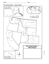
Use a printable outline map that depicts the western United States. It can be used as a reference tool as students continue to build their knowledge of U.S. geography or created as a features map, where students discuss the landforms, cities and capitals, or the various population densities in various states. The use of this outline is endless and can be adapted for grades 1-8.
Grade:
5 |
6 |
7 |
8
+ show tags

Scott Foresman, an imprint of Pearson

Provided by Scott Foresman, an imprint of Pearson, the world's leading elementary educational publisher. Its line of educational resources supports teachers and helps schools and districts meet demands for adequate yearly progress and reporting.
loading gif