"The greatest potential for loss of life related to a hurricane is from the storm surge." Brian Jarvinen, National Hurricane Center
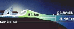 Storm surge is simply water that is pushed toward the shore by the force of the winds swirling around the storm. This advancing surge combines with the normal tides to create the hurricane storm tide, which can increase the mean water level 15 feet or more. In addition, wind-driven waves are superimposed on the storm tide. This rise in water level can cause severe flooding in coastal areas, particularly when the storm tide coincides with the normal high tides. Because much of the United States' densely populated Atlantic and Gulf Coast coastlines lie less than 10 feet above mean sea level, the danger from storm tides is tremendous.
The level of surge in a particular area is also determined by the slope of the continental shelf. A shallow slope off the coast will allow a greater surge to inundate coastal communities. Communities with a steeper continental shelf will not see as much surge inundation, although large breaking waves can still present major problems. Storm tides, waves, and currents in confined harbors severely damage ships, marinas, and pleasure boats.
In general, the more intense the storm, and the closer a community is to the right-front quadrant, the larger the area that must be evacuated. The problem is always the uncertainty about how intense the storm will be when it finally makes landfall. Emergency managers and local officials balance that uncertainty with the human and economic risks to their community. This is why a rule of thumb for emergency managers is to plan for a storm that is one category higher than what is forecast. This is a reasonable precaution to help minimize the loss of life from hurricanes.