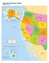
Use a printable map to provide a political view of the United States. This social studies reference shows major U.S. rivers, the Great Lakes, the national capital, state capitals, and other large cities.
Provided by Scott Foresman, an imprint of Pearson, the world's leading elementary educational publisher. Its line of educational resources supports teachers and helps schools and districts meet demands for adequate yearly progress and reporting.