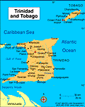
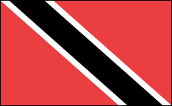
GeographyTrinidad and Tobago lie in the Caribbean Sea off the northeast coast of Venezuela. Trinidad, the larger at 1,864 sq mi (4,828 sq km), is mainly flat and rolling, with mountains in the north that reach a height of 3,085 ft (940 m) at Mount Aripo. Tobago, at just 116 sq mi (300 sq km), is heavily forested with hardwood trees. GovernmentParliamentary democracy. HistoryWhen Trinidad was explored by Columbus in 1498, it was inhabited by the Arawaks; Carib Indians inhabited Tobago. Trinidad remained in Spanish possession, despite raids by other European nations, until it was ceded to Britain in 1802. Tobago passed between Britain and France several times, but it was ultimately given to Britain in 1814. Slavery was abolished in 1834. Between 1845 and 1917, thousands of indentured workers were brought from India to work on sugarcane plantations. In 1889 Trinidad and Tobago were made a single colony. Partial self-government was instituted in 1925, and from 1958 to 1962 the nation was part of the West Indies Federation. On Aug. 31, 1962, it gained independence and on Aug. 1, 1976, Trinidad and Tobago became a republic, remaining within the Commonwealth. While the country is a stable democracy and enjoys the highest living standards in the Caribbean thanks to oil revenue, tension between East Indians and blacks has underlined much of political life. In 1970 the tension was the underlying cause of riots, protests, and an army mutiny for the end of foreign influence over the economy. These events prompted a state of emergency which lasted for two years. Eric Williams, "Father of the Nation" and leader of the People's National Movement (PNM), which is largely supported by blacks, governed from 1956 until his death in 1981. In Dec. 1986 the multiracial National Alliance for Reconstruction (NAR), based in Tobago, won a parliamentary majority, promising to sell most state-owned companies, reorganize the civil service, and reduce dependence on oil. In 1990, to protest the NAR government, some 100 radical black Muslims blew up the police station in an attempted coup, in which the prime minister and other officials were held hostage for six days. The NAR was defeated in 1991, and the PNM returned to power. In 1995, the East Indian-based party, the United National Congress (UNC), led by Basdeo Panday, formed a coalition government with the NAR. In 2000, Panday narrowly won another term. In Dec. 2001 elections, the governing UNC Party and the PNM Party gained 18 seats each. The two parties agreed to allow President Robinson to select the prime minister to end the impasse. But when Robinson chose Patrick Manning of the PNM because of his "moral and spiritual values," the opposition angrily called for new elections. In the Oct. 2002 elections, Manning's party declared victory. Maxwell Richards, a university dean, was selected president by parliament in 2003. In April 2006, former prime minister Panday was sentenced to two years in prison for committing fraud in public office. Richards, running unopposed, was reelected in February 2008. See also: Caribbean Clip Art Image | ||||
Trinidad and Tobago
Learn about the history, geography, and government of Trinidad and Tobago—Caribbean islands that gained independence from Great Britain in 1962.
Subjects: