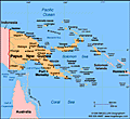
GeographyPapua New Guinea occupies the eastern half of the island of New Guinea, just north of Australia, and many outlying islands. The Indonesian province of West Papua (Irian Jaya) is to the west. To the north and east are the islands of Manus, New Britain, New Ireland, and Bougainville, all part of Papua New Guinea. About one-tenth larger than California mountainous interior has only recently been explored. Two major rivers, the Sepik and the Fly, are navigable for shallow-draft vessels. GovernmentConstitutional monarchy with parliamentary democracy. HistoryThe first inhabitants of the island New Guinea were Papuan, Melanesian, and Negrito tribes, who altogether spoke more than 700 distinct languages. The eastern half of New Guinea was first explored by Spanish and Portuguese explorers in the 16th century. In 1828, the Dutch formally took possession of the western half of the island (now the province of West Papua [Irian Jaya], Indonesia). In 1885, Germany formally annexed the northern coast and Britain took similar action in the south. In 1906, Britain transferred its rights to British New Guinea to a newly independent Australia, and the name of the territory was changed to the Territory of Papua. Australian troops invaded German New Guinea (called Kaiser-Wilhelmsland) in World War I and gained control of the territory under a League of Nations mandate. New Guinea and some of Papua were invaded by Japanese forces in 1942. After being liberated by the Australians in 1945, it became a United Nations trusteeship, administered by Australia. The territories were combined and called the Territory of Papua and New Guinea (PNG). Australia granted limited home rule in 1951. Autonomy in internal affairs came nine years later, and in Sept. 1975, Papua New Guinea achieved complete independence from Britain. A violent nine-year secessionist movement took place on the island of Bougainville. In 1989, guerrillas of the Bougainville Revolutionary Army (BRA) shut down the island's Australian-owned copper mine, a major source of revenue for the country. The rebels believed that Bougainville deserved a greater share of the earnings for its copper. In 1990, the BRA declared Bougainville's independence, whereupon the government blockaded the island until Jan. 1991, when a peace treaty was signed. On July 17, 1998, an earthquake-triggered tsunami off the northern coast of PNG killed at least 1,500 people and left thousands more injured and homeless. Many analysts say Papua New Guinea is in danger of political and economic collapse. The country's political system is unstable, the crime rate has soared, corruption is rampant, and essential services including health care and education continue to decline. According to the World Bank, 70% of the country lives in poverty. In 2006, Australia announced that it was gravely concerned about the country and had peacekeeping forces at the ready. Somare was elected to a second consecutive term as prime minister in August 2007, defeating Sir Julius Chan. | ||||


©2022 Sandbox Networks Inc. All rights reserved. Sandbox Learning is part of Sandbox & Co., a digital learning company.
