Map of the Arctic & Antarctica

Download
Add to Folder
creative writing
children's book
activities
classroom tools
language arts and writing
vocabulary
Create new folder
CREATE NEW FOLDER
Share
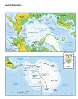
This printable colored map of the Arctic and Antartica is a great printable resource to build students geographical skills. This is an excellent way to challenge your students to color label all key aspects of these countries. This is a great resource to use in your classroom to teach your students about the development of the section, its' various cities, geologic formations, rivers and more.

Scott Foresman, an imprint of Pearson

Provided by Scott Foresman, an imprint of Pearson, the world's leading elementary educational publisher. Its line of educational resources supports teachers and helps schools and districts meet demands for adequate yearly progress and reporting.
loading gif